Posts by Mrwilliamsburg.com

Mrwilliamsburg.com's avatar

Mid County Park-James City County

Mid County Park

Website: Go To Website

kidsburg1
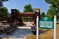
Come to this 19-acre facility that has something for the whole family.  For the adults, enjoy lighted recreation areas , basketball and tennis courts, as well as sand volleyball courts. Enjoy the paved 2/3 mile ADA accessible multi-use path that encircles the park. For the children, play at Kidsburg, a community-built playground that has become an area attraction.  Planning a small family outing, family reunion, or perhaps a group meeting – then you may want to consider Mid County Park.  There is a large picnic shelter and a small picnic shelter and spacious play areas for games or other functions.  The park hours are from sunrise to sunset daily.  The park is staffed daily from Memorial Day to Labor Day and weekends only the rest of the year.  Access to the park is free and if you want to reserve a shelter or field, check out our low fees!

Mrwilliamsburg.com's avatar

McCormack Nagelsen Tennis Center

McCormack Nagelsen Tennis Center

Website: Go To Website

The McCormack-Nagelsen Tennis Center features six indoor tennis courts using the GreenSet GrandPrix Surface (rubberized base under color coat), air conditioning and indirect lighting at a competitive level. The facility also includes member and team locker rooms, several spacious lobbies and spectator viewing that boasts 362 stadium seats as well as a mezzanine seating area. In addition, the ITA and Rolex generously donated a state-of-the-art electronic scoreboard.
The Intercollegiate Tennis Association’s Women’s Tennis Hall of Fame contains a collection of artifacts and records pertaining to collegiate women’s tennis, and enshrines former players, coaches and contributors that have impacted the sport. The Hall of Fame also functions as a library, archive and research center for intercollegiate women’s tennis.

Mrwilliamsburg.com's avatar

Golden Horseshoe Golf Club-Williamsburg

golden horseshoe golf williamsburgGolden Horseshoe Golf Club | Williamsburg VA Golf Course

Just a chip shot from Colonial Williamsburg’s Historic Area, the Golden Horseshoe’s internationally acclaimed Gold and Green courses and executive-length Spotswood Course are emeralds in the crown of The Resort Collection of Colonial Williamsburg. Free from any bordering residential development, the courses are surrounded by mature woodlands and ravines and designated as Audubon sanctuaries. The Golden Horseshoe has been honored with Golf Magazine’s Gold Medal Award, received 4½ stars in Golf Digest’s20062007 Places to Play,” and is listed in the Zagat Survey as one of “America’s Top Golf Courses.”

The Gold Course
The Gold Course, designed by famed architect Robert Trent Jones Sr., offers what great golf courses should: a spectacular setting with plenty of risk/reward decisions. Jones called it his “finest design.” The Gold Course’s 16th and 17th holes are counted among the “Top 500 Golf Holes in the World” by GOLF Magazine.

Par from the championship tee is 71 over the 6,817-yard course. Seven holes pose water hazards. The longest par-5, the 15th, measures 634 yards from the championship tee. The shortest hole, the par-3 16th hole, plays without a fairway to an unforgettable island green. Listed in “America’s 100 Greatest Public Courses” by Golf Digest, the Gold Course was the site of the 2007 NCAA Division I Men’s Golf Championship.

The Green Course
Who better to create the Golden Horseshoe’s Green Course than Robert Trent Jones’s son Rees, a brilliant designer heralded by many as the “Open Doctor” for his seven U.S. Open designs? Rees took his father’s lead in designing the Green Course to the landscape, giving it rolling fairways carved from majestic woods. According to Jones, “The course defines the shot, but gives the player several options. It’s a shotmaker’s course.”

Offering fairways and rough carved from 20 acres of mature woodland, the Green Course is a par-72 from the championship tees and measures more than 7,120 yards in length. Water comes into play on six holes, with two played over water and four with lateral hazards. It’s challenging enough to have served as the site of the 2004 U.S Women’s Public Links Championship.

The Spotswood Course
A relaxing challenge is what the Spotswood Course is all about. With six par-3s, two par-4s, and one par-5, Robert Trent Jones Sr.’s update of the Williamsburg Inn’s original 1947 nine-hole course offers a great test of a golfer’s skill. GOLF Magazine called it the “best short nine-hole course in the country,” and Golf Range Magazine considers it one of the “Top Short Courses in America.”

401 SOUTHENGLAND ST. •WILLIAMSBURG, VA 23185
T: 757-220-7696 • WWW.COLONIALWILLIAMSBURG.ORG

Mrwilliamsburg.com's avatar

Golfing in Williamsburg

Some of the greatest names in golf course design have left their mark here in Williamsburg. Robert Trent Jones Sr., Arnold Palmer, Pete Dye, Mike Strantz, and Nicklaus Design Associates have earned our courses various “Top 10” awards over the years.

Read more here

Country Club @ Fords Colony (7)FORD’S COLONY COUNTRY CLUB 54 holes of Championship golf, a grand clubhouse, and excellent staff await your play at Ford’s Colony. Winding through the pastoral heart of the Ford’s Colony community, this club offers the highest ranked courses in Virginia. A favorite of golfers from throughout the East Coast, Ford’s Colony has been awarded four-and-a-half stars by Golf Digest’s Places to Play.

Legendary course designer Dan Maples created all three courses with a solid appreciation of all levels of play. Blackheath, Marsh Hawk, and Blue Heron, each offers its own challenge, reward, and golfing enjoyment. Be sure to visit the well-appointed pro shop, and after your round, relax in Harry’s Tavern—a perfect end to a day of golfing.

ONE FORD’S COLONY DRIVE •WILLIAMSBURG, VA 23188

757-258-4130 • WWW.FORDSCOLONY.COM

Mrwilliamsburg.com's avatar

Redoubt Park Williamsburg

Redoubt Park
This beautiful, wooded 22-acre park preserves and interprets two of the fourteen Civil War earthworks forts – or redoubts – which made up the Confederate’s Williamsburg Line in the Battle of Williamsburg. This engagement on May 5, 1862, resulted in more than 3800 Union and Confederate casualties and left the Union in control of the Virginia Peninsula. 757-259-3760

Mrwilliamsburg.com's avatar

Chickahominy Riverfront Park-James City County

Come enjoy this 140-acre park located on the Chickahominy River.  This park has something for every member of your family to enjoy.  Facilities include two outdoor swimming pools, boat ramp, fishing pier, camp sites, a playground, picnic shelters, a small store and access to the Virginia Capital Trail.  You can bring your own boat or rent one at the park to enjoy fishing or exploring the Chickahominy River and Gordon Creek.  There is space for monthly rental of boat and RV storage. The large fields and picnic shelters are available for special events.

Mrwilliamsburg.com's avatar

Matoaka Trails in Williamsburg

Matoaka Trails

With more than 10 miles of trails surrounding Lake Matoaka, the College Woods are a recreational and educational outlet for the community. The Civilian Conservation Corps developed a majority of the trails in the early 1930s.  If you can approach the run as an adventure and you have a flexible timeframe, then park at New Town and pick up the trail off Monticello or the entrance that’s just down from the William & Mary Athletic Center. Some sections are well maintained, others are not. This is by far the most challenging of the soft-surface runs in the area (imagine the twisting hill of Mill Neck Road, then add mud, roots, logs….). Parts of the trail are deeply rutted and you’ll pick your way across fallen logs if you loop around the lake, but the sections of the trail offer a great view of Lake Matoaka, so it’s worth a try. There are many places to access this trail, click to see a map.

Mrwilliamsburg.com's avatar

Hiking at York River State Park

5526 Riverview Road
Williamsburg, VA 23188

›› Google Map

More than 25 miles of hiking, biking and equestrian trails provide access to the parks beautiful and diverse natural areas.

Hiking Trails At York River State Park

Backbone Trail

The Backbone Trail is a wide 1.5 mile, moderate difficulty, multi-use trail that runs south from the Contact Station to the southern part of the park. The trail is open to hiking and biking for its entire length, however equestrians are permitted only south of Black Bear Run. The trail is accessible from the Contact Station, and from the Beaver, Woodstock Pond, Laurel Glen, Black Bear Run, Pumunkey, Powhatan Forks, Riverview, White-tail, and Me-Te-Kos trails. It passes through hardwood forest rich with wildlife and featuring numerous views of the park and surrounding areas.

Blaze Color: Gold

Usage:

HikingMountain BikingHorseback Riding

View Video Tour | Download Trail Map

yorkriver

  • Length: 1.73
  • Difficulty: Moderate
  • Surface: Sandy Earth, Gravel
Beaver Trail

The Beaver Trail is a 0.5 mile, easy trail for hiking only, that connects the Backbone Trail to the Woodstock Pond Trail near its northern Mataponi Trail access. The trail closely follows the south side of Woodstock Pond through wooded and marsh areas. Several boardwalks aid hikers in the wetter areas.

Blaze Color: Silver

Usage:

Hiking

View Video Tour | Download Trail Map

yorkriver

  • Length: 0.5
  • Difficulty: Easy
  • Surface: Earth
Dogwood Lane Trail

The Dogwood Lane Trail is a .8 mile, easy multi-use trail that is accessible in two places from the White Tail Trail. It makes a semi-circle as it passes through the woods, coming out at another point on the White Tail Trail. The path here is narrower than on the neighboring trail and is somewhat more scenic.

Blaze Color: Bronze

Usage:

HikingMountain BikingHorseback Riding

View Video Tour | Download Trail Map

yorkriver

  • Length: 0.76
  • Difficulty: Easy
  • Surface: Earth
Majestic Oak Trail

The Majestic Oak Trail is a .74 mile, moderate difficulty multi-use trail that is accessible from the Spurr Trail and the Powhatan Fork Trail. The trail passes through the woodland environment that typifies the park. It is named because, near its end, the trail passes an ancient oak tree that is estimated to be between 200 and 400 years old and is believed to be the oldest oak in the park. Past this giant tree, and toward the river, the trail is no longer suitable for horses, riders will need to return to the Spur Trail. Near the York River the trail winds down a steep bank where a bridge crosses the marsh. From the bridge, the trail winds up the bank and becomes the north fork of the Powhatan Fork Trail.

Blaze Color: White

Usage:

HikingMountain BikingHorseback Riding

View Video Tour | Download Trail Map

yorkriver

  • Length: 0.8
  • Difficulty: Moderate
  • Surface: Earth
Mattaponi Trail

The Mattaponi Trail is a .85 mile, easy hiking trail that is accessible in two places from the Woodstock Pond Trail and provides access to the fossil beach, where shark teeth and other fossilized material may be found. Named for the Indians who once inhabited the area, the trail passes along wooded cliffs and across marshes all offering good views of the York River. South of the fossil beach access, the trial becomes wider and the area becomes grassier. A long bridge spans the marsh at one place and on either side of it the trail is fairly steep.

Blaze Color: Lt. Blue

Usage:

Hiking

View Video Tour | Download Trail Map

yorkriver

  • Length: 0.85
  • Difficulty: Easy
  • Surface: Boardwalks, Earth
Powhatan Fork Trail

The Powhatan Fork Trail is a 1.6 mile, moderate difficulty multi-use trail, that is accessible from the Backbone, Majestic Oak, Spurr, and Riverside Trails. A wide, gently downhill sloping trail it passes mainly through wooded areas and has two forks. The east fork takes users towards the river where there is a bench at the top of the cliff with panoramic views of the surrounding area. The north fork takes users into the salt marshes. The portion of the trail that connects to the Majestic Oak Trail is not suitable for horses, as it winds down into the marsh and crosses a footbridge where it joins the other trail.

Blaze Color: Beige

Usage:

HikingMountain BikingHorseback Riding

View Video Tour | Download Trail Map

yorkriver

  • Length: 1.6
  • Difficulty: Moderate
  • Surface: Earth
Pumunkey Trail

The Pumunkey Trail is a 0.9 mile, moderate difficulty multi-use trail, that is accessible from both the Backbone Trail and the Spur Trail. Named for another tribe of Indians who once inhabited the region, this trail takes users from the Backbone or Spurr Trails downhill to an observation tower that overlooks the York River. Bikers should use caution as portions of the trail are steep and sandy. The trail passes through the forested areas that are typical of this park.

Blaze Color: Yellow

Usage:

HikingMountain BikingHorseback Riding

View Video Tour | Download Trail Map

yorkriver

  • Length: 0.9
  • Difficulty: Moderate
  • Surface: Earth
Riverview Trail

The Riverview Trail is a 1.44 mile, moderate difficulty multi-use trail that leads from the Backbone Trail to the southernmost access to the York River. The trail is also accessible via a short connector to the Powhatan Forks Trail. It passes through a wooded area and, not far from the river, is blocked by a fence with a pass-thru for hikers only. Bicycle and horseback riders must proceed on foot from this point. The remote location of this trail makes it especially suited for observing wildlife. Near the beach the trail becomes sandy and observant hikers will often spot evidence of the abundant wildlife that inhabit this area. At the end of the trail there is a seating area where one can relax before returning to the trail head.

Blaze Color: Dark Blue

Usage:

HikingMountain BikingHorseback Riding

View Video Tour | Download Trail Map

yorkriver

  • Length: 1.44
  • Difficulty: Moderate
  • Surface: Earth
 

The Spur Trail is a short, easy, connecting trail between the Powhatan Forks, Majestic Oak, and Pumunkey Trails. Near its southern end a 1940s era house once stood. Before it was torn down some believed that the abandoned home was haunted. Check out the popular Ghost Hike program if you are dying to find out more about this story.

Blaze Color: Black

Usage:

HikingMountain BikingHorseback Riding

View Video Tour | Download Trail Map

yorkriver

  • Length: 0.4
  • Difficulty: Easy
  • Surface: Earth
Taskinas Trail

The Taskinas Creek Trail is a 1.5 mile hiking loop that is accessible near the horse trailer parking just south of the Visitor Center. It can also be accessed near the northernmost Meh-Te-Kow Challenge Loop access point. The trail passes through a variety of habitats ranging from field to forest. At the halfway point the trail takes hikers along Taskinas Creek Marsh Area where they may see ospreys and great blue herons from the four observation decks that have been built by local Eagle Scouts. This is a trail loop with numerous changes in elevation.

Blaze Color: Red

Usage:

Hiking

View Video Tour | Download Trail Map

yorkriver

  • Length: 1.5
  • Difficulty: Moderate
  • Surface: Earth, Boardwalks, Steps
White-tail Trail

The White-Tail Trail is a .76 mile, moderate difficulty multi-use trail that is accessible from the Backbone Trail and provides subsequent access in two places to the Dogwood Lane Trail. The trail passes through the woods bringing users to an area where the trail ends and users must turn around. When combined with the Dogwood Trail this trail makes an interesting loop through shaded forest. Near the end of the trail, seasonal views of the river may be had through he trees.

Blaze Color: Brown

Usage:

HikingHorseback RidingMountain Biking

View Video Tour | Download Trail Map

yorkriver

  • Length: 0.8
  • Difficulty: Moderate
  • Surface: Earth
Woodstock Pond Trail

The Woodstock Pond Trail is a 1.5 mile easy trail for hikers and bikers. It is accessible near shelter 3, from the Backbone Trail, as well as from the Beaver Trail. The trail provides access to the Mataponi Trail. This wide dirt and fine gravel trail takes users from the Visitor Center over the dam and around Woodstock Pond, returning to the Backbone Trail. On this trail you will go near the sites where the Woods House (1930) and the Henderson House (pre-1817) once stood. The trail features fitness stations with chin up bars, monkey bars, and platforms for doing push-ups and sit-ups.

Blaze Color: Gray

Usage:

HikingMountain Biking

View Video Tour | Download Trail Map

Mrwilliamsburg.com's avatar

Horseback Riding Around Williamsburg VA

Horseback Riding

If a ride on your favorite horse is what you need to shed the stress of everyday life, you won’t find more beautiful country to ride that the mountains of Northwestern Virginia. With several state and national parks offering trail access to equestrians, you’ll also want to add the George Washington and Jefferson National Forests to your list places to see from horseback, just to name a few. So saddle up and let’s hit the trail!

Use the links below to download the Virginia Horse Council’s directory of primary horse trails and trail heads in Virginia that have public access. Right-click on the links and choose "Save Target/Link As…" to copy to your computer. Adobe Reader 6 or greater required:

Central Virginia Section (PDF)

Eastern Virginia Section (PDF)

Tidewater Virginia Section (PDF)

Mrwilliamsburg.com's avatar

Fishing at York River State Park-Williamsburg

You’ll find great fishing in three areas of the park. Freshwater anglers will find bluegill and largemouth bass in Woodstock Pond. A Virginia fishing license is required. Boats are available seasonally for rent on pond. Only rental boats are allowed on the pond. The York River, where catfish, spot, croaker, striper and crabs are plentiful, is accessed at Croaker Landing. Taskinas Creek, which has catfish and white perch, requires either a valid saltwater or freshwater Virginia fishing license. Motorboats are allowed only on the river. Rental boats have no motors.

The York River, where catfish, spot, croaker, striper and crabs are plentiful, is accessed at Croaker Landing. The landing has a boat launch dock, a 360-foot fishing pier, parking and restrooms. Those fishing from boats and the shore must have a Virginia saltwater fishing license. You can buy an annual pass for parking, boat launching and pier fishing at the park or by calling 1-800-933-PARK. Parking and launch-fishing pier fees are required at all times. Croaker Landing is open from 6 A.M. to dusk May 1st through Labor Day and 8 A.M to dusk Labor Day through May 1st.

  • Season/Hours: All Year/See Summary
  • Fee: Park Fees
  • Location:37° 25.6250 -76° 43.5150

yorkriver

Fishing Woodstock Pond

Freshwater anglers will find bluegill and largemouth bass in Woodstock Pond. A Virginia fishing license is required. Boats are available seasonally for rent on pond. Only rental boats are allowed on the pond.

  • Season/Hours: All Year/Call Park (757) 566-3036
  • Fee: Park Fees
  • Location:37° 24.7400 -76° 42.7330

yorkriver

Fishing Taskinas Creek

Taskinas Creek, which has catfish and white perch, requires either a valid saltwater or freshwater Virginia fishing license. Canoes and kayaks are available for rent at the creek.

  • Season/Hours: All Year/Call Park (757) 566-3036
  • Fee: Park Fees
  • Location:37° 24.9140 -76° 42.8540

yorkriver

Other Activities At York River State Park: Biking, Boating and Water Sports,Educational Activities, Gifts and Shopping, Hiking, Horseback Riding, Hunting, Picnicking and Canoeing And Kayaking

Click here to return to the destination overview for York River State Park, or check out other great Virginia outdoor destinations that offer access to Fishing.

Mrwilliamsburg.com's avatar

Chippokes Plantation State Park-Surry

Just a short ferry ride from Williamsburg lies a state park with a working farm with all kinds of animals, crops and historic buildings.  The park also boast museums dedicated to farming, fossils and early plantation life.  Top that off with Cobham Bay Beach and a pool for swimming and what’s not to love?

Jamestown and Colonial Williamsburg, with all  they have to offer, are on the other side of the bay and a 20 minute ferry ride away.  The ferry ride alone  is just plain fun.

I’ve hiked most of the trails here and will tell you it’s flat as a pancake and easy walking.  I would highly encourage anyone to visit Chippokes which is only about an hour or so from Richmond, VA Beach and totally worth the drive.

Chippokes Plantation State Park is one of the oldest working farms in the United States. Chippokes is a living historical exhibit located in a rural agricultural area along the James River in Surry County. In addition, the park has a wide variety of traditional park offerings, including a swimming complex, visitor center, picnic facilities, and hiking and biking trails. The plantation has kept its original boundaries since the 1600s and has a variety of cultivated gardens and native woodland. The formal gardens surrounding the Chippokes Mansion are accented by azaleas, crepe myrtle, boxwood and seasonal flowers. The plantation grounds are also home to the Chippokes Farm and Forestry Museum.

Chippokes Plantation State Park is operated by the Department of Conservation and Recreation in cooperation with the Chippokes Plantation Farm Foundation. The Virginia General Assembly created the foundation in 1977 to establish, administer and maintain the model farm. Funding for the foundation comes from farmland rent payments, donations, admissions and gift shop sales.

Park Size: 1,683 acres.
Current Weather: Click here to visit the Weather Channel’s site for this zip code.

AT-A-GLANCE: The pictographs directly below show park offerings. Click on those of interest or read below for more detail. Mouse-over the image for a short text description or click here to view a legend in which each pictograph’s meaning is expressed.

some wheelchair accessability Amphitheater Bike Trails Cabins Camping Fishing Food/Restaurant Hiking Trails Horse Trails Parking Fee Picnic Shelters Restrooms RV Sites Sanitary Disposal Facilities Showers Camp Store Swimming

Map: Park Location for Chippokes PlantationLOCATION: Surry County. From I-95 and I-295, take Route 10 towards Hopewell. Follow Route 10 East for approximately 40 miles to Surry. Turn left at the intersection of routes 10 and 31 (this continues on Route 10). Turn right at the stop light. Turn left at Route 634 (Alliance Road), and the park entrance is four miles on the left.

Drive Time: Northern Virginia: 2 – 3 hours; Richmond: 1.5 hours; Tidewater/Norfolk/Virginia Beach: 1.5 hours; Roanoke: 4 hours


OVERNIGHT FACILITIES: Cabins and camping. For information on availability of overnight accommodations, particular park amenities or to make a reservation, you can reserve online or call 1 1-800-933-PARK. Rental rates for cabins and camping vary by season, dwelling and park. First, determine the appropriate season, which can vary by park, then the relevant rate.You also may want to learn about cancellation and transfer policies. A fee is charged per pet per night for overnight stays.

SWIMMING: Note: From mid-August through Labor Day, swimming may be available only on weekends and Labor Day. If your stay depends on using the pool, please contact the park before making a reservation. Olympic size swimming pool and separate kiddie pool open Memorial Day to Labor Day, Monday through Thursday, noon to 6 p.m.; on Friday through Sunday and holidays, 10 a.m. to 7 p.m.. Click here for park fees.

In the summer, swimming is free for overnight guests in campsites, cabins and the lodge, however it cannot be guaranteed should circumstances beyond the park’s control require that swimming be closed. We do not give refunds for swimming to overnight guests under any circumstances.

TRAILS: The park has 3.5 miles of hiking and bicycling trails, a half-mile of which is accessible to people with physical disabilities, through the historic area, as well as an auto farm tour road. The park also has an equestrian area with about 10 miles of riding fun available around farm fields as well as two long, multiple-use trails.

Explore Virginia Outdoors link iconVisit the Explore Virginia Outdoors website for enhanced maps and video tours of Chippokes Plantation’s trails.

WILDLIFE: Virginia State Parks are great places to discover and reconnect with the wild world. Bring a camera and share your captures with the world. But please don’t disturb or get too close to the animals. The park is, after all, their home. Here are a few recent natural encounters others have had at Chippokes Plantation.

John

Mrwilliamsburg.com's avatar

Waller Mill Park-Williamsburg

imageWaller Mill Park is located on Airport Road (Rt. 645) between I-64 and Rt. 60 West, is the City’s 2705-acre park situated around its reservoir that was opened to the public in July 1972. The 286-acre lake is open for fishing, boating, pedal boating, canoeing and kayaking with a tunnel connecting the upper and lower sections of the lake. Numerous picnic tables, four shelters, play fields, and playground equipment are nestled among the trees providing a scenic picnic area. The shelters can accommodate 25-150 people.

Hiking trails provide an interesting, picturesque walk with water and wooded views. A two-mile asphalt bike trail offers a scenic connection between Mooretown and Rochambeau Roads. A short hike from the park along the asphalt bike trail will bring you to the Lookout Tower, which offers a panoramic view of the water and woodlands. In an effort to preserve the natural characteristics of the park, feeding of wildlife is prohibited.

The Waller Mill Dog Park is a joint venture between the City of Williamsburg and James City County.  Click on this link for more information about Waller Mill Dog Park.

Waller Mill Park has four shelters with a variety of amenities. Please call (757) 259-3778 to check date availability and prices.  Click on this link for more information about our shelters.

Click on the following pdf files for additional Waller Mill Park information:

2012 Hours of Operation (pdf file)

2012 Fee Schedule (pdf file)

Brochure: Waller Mill Park (pdf file)

Brochure: Waller Mill Dog Park (pdf file)

Waller Mill Park Rules (pdf file)


The Waller Mill Dog Park, which is located at Waller Mill Park on Airport Road, is approximately 1½ acres. It has two areas, one for small dogs, 20 lbs. or less, and an area for larger dogs over 20 lbs. .
The park allows dog owners to let their dogs run freely within the fenced-in boundaries. Prior registration is required in order to access the park and all owners/handlers must read and agree to abide by the dog park rules. This project is a joint venture between the City of Williamsburg and James City County. All dog owners using the dog park, whether daily access or membership, must present their dog license certificate and their rabies vaccination certificate.  This paperwork is required to access the Waller Mill Dog Park.

Annual Membership & Daily Access Information:

(for dogs in the same family)

Williamsburg & James City County Residents (prices include entrance fee):
$27 – 1st dog   
$10 – each additional dog

Non-Residents (prices include entrance fee):
$62 – 1st dog
$25 – each additional dog

Daily Access Pass (price does not include entrance fee):
$2 – per day / per dog

Before Entering the Dog Park :

  • Register your dog(s) at the Operations Building .

  • The following information must be provided at the Park Office:

    1. The name, age, address, telephone number, and email address of the owner of the dog.
    2. The name, age, address, telephone number, and email address of any person who does not own the dog, but has custody of the dog. 
    3. The name, approximate age, and breed of the dog 
    4. Registration paperwork for your dog license from your City or County of residence.
    5. Paperwork indicating all vaccinations are current.
  • Each dog allowed to enter the Dog Park must have a current dog license and a current rabies vaccination as well as any other vaccinations required by law.

If you would like more information regarding the Waller Mill Dog Park , please contact the Williamsburg Parks and Recreation Department at (757) 259-3760, Waller Mill Park at (757) 259-3778 or email.

Waller Mill Dog Park Brochure (PDF)

Complete Waller Mill Dog Park Rules & Regulations (PDF)

Mrwilliamsburg.com's avatar

Mountain Biking in New Kent-Wahrani Park

Wahrani Park

Wahrani Nature Trails

Chesapeake Forest Products Company opened this trail property in 1973 to help develop a public appreciation for the natural environment. The trails were opened to mountain bikes in 2007 to make this facility a multi-use trail for bikers, walkers, and joggers. Trails are currently marked by colored blazes on trees along the trails. Future improvements and development plans include adding a picnic area, a fittrail system, a restroom facility and re-marking of the trails.

Location:

West Point, Virginia

Directions from Peninsula:

From I-64 take Exit 227. Merge right onto Route 30 heading towards West Point. After 6.6 miles turn right at traffic light onto Route 33. After 3/4 mile turn right into driveway at Wahrani Nature Trail.
Directions from Richmond:

From I-64 take Exit 220. Merge onto Route 33 heading towards West Point. Wahrani Nature Trail is on the right 3/4 mile past the first traffic light.
Description:

Trail Level: Intermediate
Trail Type: Singletrack
This is a multi-loop bi-directional single track trail system, about 5 miles long, with interesting terrain and challenging technical features. It has more elevation change than any of the peninsula trails. Some sections of the trail system are designated for hikers only due to erosion concerns.

Trail Map from GPSTrailSource.com

Trail Review from mtbr.com

image

Mrwilliamsburg.com's avatar

Mountain Biking at York River State Park in Upper York County-Williamsburg

York River State Park

Location:
5526 Riverview Road
Williamsburg, Virginia 23188
Directions:
From I-64 take exit 231B onto Croaker Road (Route 607). Turn right onto Moss Side Lane after 1 1/2 miles. At the end of Moss Side Lane bear right onto Riverview Road. Turn left onto York River Park Road after 1 1/2 miles. York River Park Road ends at the parking lot and visitor center.
Description of Marl’s Ravine Trail:
This trail is designed to be traveled in a counter-clockwise fashion! Follow the entry sign at the trailhead. Awesome approx. 6.0 mile loop. Lots of short, steep uphills, roots, logs, and switchbacks for your riding pleasure. About 2 miles in, there is a very steep downhill that can be very tricky. More technical and demanding than the Waller Mill trail, Marl Ravine is designed with the intermediate to advanced rider in mind. Beginning riders can finish the Marl Ravine but will probably have to push their bike up most of the climbs and over the more technical sections.

Description of Laurel Glen Trail:

Laurel Glen trail is designed for the beginning to intermediate rider. At about 2 miles in length, Laurel Glen has a couple of "surprises" in store for the rider. There is a really fun downhill about halfway through which is almost immediately followed by one of the two most grueling climbs in the park. Even with the downhill and the climb, beginners should be able to finish this trail with just a little walking. Intermediate to advanced riders can make this trail a multi-lap workout. Trail Notes:About halfway through the trail, you will come out onto a fire road. To continue to the downhill and the switchback climb, bear to the right off the fire road. If you would rather skip the downhill and climb, continue on the fire road until you see the single track re-entry on the left.
Park Notes:
There is a parking fee of $3.00 per person or $5.00 per carload Monday-Sunday. This is a state park fee and is not imposed by EVMA. When you pay your fee ask for a park map, it shows the location of the trails.

Trail Map: Click Here To View

Trail Map from GPSTrailSource.com

Trail Review from mtbr.com

Park Information from Virginia.gov

Mrwilliamsburg.com's avatar

Mountain Biking at Upper County Park in James City County

Upper County Park

Location:

James City, Virginia 23168
Directions:

From I-64 take Exit 227 (Toano) to Route 30 South heading towards Toano/Williamsburg. After about 1/3 mile turn right onto Old Stage Road, just before the gas station and McDonalds’s. After about 1/3 mile, turn right onto Leisure Road. Follow Leisure Road into the park.
Description:

The Upper County Park trail is a 3.7-mile loop within the 75-acre Upper County Park in James City County, Virginia. The trail begins near the end of the cul-de-sac at the end of the park entrance road. Look for the mountain bike trail signs. The trail is on the left of the chained-off gravel road that leads back into the woods. Much like other trails in the area the loop contains many quick climbs and descents through ravines that surround the creek and bottomland areas adjacent to the park. The route is somewhat technical with tight turns and off camber sections. There are, however, fast stretches that use the terrain for banked turns. One downhill contains four turns that take you from side to side in a small ravine much like a bobsled course. Although shorter than other nearby trails maintained and constructed by the Eastern Virginia Mountain Association (EVMA), the trail is no less demanding. In fact, aerobically it is one of the more challenging. Many of the climbs come one after the other with few flat areas to recover. This trail requires attention. You will find it hard to take you hands off the bar to grab a water bottle or even your hydration pack hose. The trail sees little use, so expect a few sticks and branches and a narrow tread through the will blueberry (lowbush) which covers much of the forest floor along the trail.
The trail was designed to be ridden clockwise but can be ridden in both directions. In fact, counter clockwise seems to require more climbing and it will take you a bit longer to complete a loop. You can also ride the trail in a figure eight since there is a cross over near the mid-way point. Also, if you are riding clockwise, look for a bailout near the 3-mile point. The bailout drops you in on an old gravel road that makes a loop through the woods starting near the trail entrance. The gravel road was part of the old campground that previously existed at the site. In fact, you will see electrical boxes for the old campsites along sections of the trail.
In the summer, after your ride, plan to cool off in the park pool. While there is no fee for park admission or riding, a fee is charged for use of the pool. Other amenities at the park include children’s playground equipment and an outdoor basketball court. Pavilions are also available for a fee. Next time you ride, take the family. They can enjoy the pool and playgrounds.

Trail Map: Click For Map

Trail Map from GPSTrailSource.com

Trail Review from mtbr.com

Mrwilliamsburg.com's avatar

Mountain Biking at New Quarter Path Park in York County

New Quarter Park

Location:

1000 Lakeshead Drive
Williamsburg, VA 23185
Directions to New Quarter Park:

From I-64 take exit 242A on to Route 199. After about a mile look for large green sign “143 Williamsburg” and take that exit bearing right onto Merrimac Trail heading toward Williamsburg. Turn right at the traffic light past the 7-11 Store (about 1.3 miles) onto Penniman Drive. Pass the school and take the next left onto Hubbard Lane. After about 1 mile+ turn right onto Lakeshead Drive. There is a green sign for New Quarter Park at the intersection of Hubbard and Lakeshead. Lakeshead Drive ends at the park (a little over a mile). If you park to your left the trail head is along the right of the tree line Across The field in front of you

Description:

Trail Level: Intermediate
Trail Type: Singletrack
This trail was designed and built by the Eastern Virginia Mountain bike Association (www.evma.org).  This is another great trail built and maintained by the Eastern Virginia Mountain bike Association (www.evma.org). Part of the Confederate Defensive Line was on this property and there are three Civil War dugouts clearly visible in the first mile of the trail. Please respect the area’s history by not disturbing them. The trail is a 5.8 mile single-track loop designed to be ridden counter-clockwise and is suitable for intermediate riders. Beginners will have trouble negotiating some of the tight turns and climbs, but there’s nothing dangerous to contend with. All the obstacles are either reasonable or have a ride-around. The first 3 miles follow the contours of a ravine which runs from the parking lot to the park entrance and there is barely a flat section in it – you’re going up or you’re going down! Most of the trail has good flow and sweeping turns, but there are some tight turns on downhill sections to watch out for. Once you know the trail you can carry your speed. Most of the climbing in this section of the trail is between milepost 2 and milepost 3. The second half of the trail returns to the parking lot closer to the tree line. There is less climbing and fewer sharp turns, but still enough challenge to hold your interest. The trail has an offshoot a little way past the 3 mile post. Go straight for a shortcut or turn right for more of a challenge. At the next split in the trail, go left for a large log pile, or right to detour around it. After a double switchback climb and an uprooted tree made into a smooth ride-over is about the only flat area of the trail. It’s fast and fun so make the most of it because there’s more climbing ahead. When you get to bumps like plow furrows you’re almost done. If you’ve missed riding at Waller Mill since Hurricane Isabel, you need to check out this trail.

Trail Map: Click Here To View

Trail Reviews from mtbr.com

Trail Map from GPSTrailSource.com

Mrwilliamsburg.com's avatar

Mountain Biking At Freedom Park in James City County

Freedom Park

Location:
5535 Centerville Rd
Williamsburg, Virginia 23188
Freedom Park has a rich historical background dating back to the 1650′s.  This park is the site of an 18th century cemetery, the Revolutionary War Battle of Spencer’s Ordinary (1781),and a 17th century domicile that is revealing much archaeological research of the early colonial period (1680-1730).

Freedom Park has a rich historical background dating back to the 1650′s.  This park is the site of an 18th century cemetery, the Revolutionary War Battle of Spencer’s Ordinary (1781),and a 17th century domicile that is revealing much archaeological research of the early colonial period (1680-1730).

This 600-acre forested retreat also features approximately two miles of hiking trails and more than 25 miles of mountain bike trails winding through historical sites, forests and along creeks, open meadows, and parking.  The bike trails were designed and built and are maintained by the Eastern Virginia Mountain Bike Association.  Trails are closed to bikes during inclement weather to prevent trail degradation. Riders are encouraged to call 259-4022 to check trails status.

Download a trail map here

Directions:
From Interstate 64 take exit 234A to Route 199. From Route 199 take the Longhill Road exit. Turn right onto Longhill Road (Route 612). Follow Longhill Road until it ends at the park gates. Once inside the park gates, follow road to the parking lot.
Description:
Trail Level: Intermediate
Trail Type: Singletrack
This trail was built and is maintained by the Eastern Virginia Mountain bike Association (www.evma.org). It’s new and doesn’t have a lot of traffic yet, so it’s still soft. The first 1/2 mile is winding and lumpy, with a couple of technical climbs, making it difficult to maintain momentum, but good for building bike handling skills. The next 2 miles aren’t as technically challenging, but there’s plenty to keep you entertained and on your toes. At times the trail is close to the property line and you may notice "No Trespassing" signs. Stay on the trail and keep the signs on your left. Some people have become confused by the signs and got themselves turned around. A little way past the second bridge the trail forks. If you’ve had enough, take the right trail for a half mile ride back to the trailhead. If you’re ready for more, take the left trail for 2 more miles of single-track. A little way into the second loop you will once again notice "No Trespassing" signs. As before, follow the trail and keep the signs on your left. Be prepared for a good dose of climbing, but the reward is a couple of nice downhill’s. The last half mile of this loop was laid out with the help of the Subaru/IMBA Trail Care Crew, and it is sweet. The trail ends at a logging road. Turn left and go about 100 ft to where the first loop crosses the road. Turn left onto the single track to exit at the trailhead, or continue on the logging road, which will also leads back to the parking lot. Beware of pungees on the logging road. This trail system is still under construction and needs additional grooming. It isn’t as long as York River or Waller Mill (yet), but will give you more of a workout than either one. The EVMA’s ultimate goal is to have 25 miles of single track at this park.

Trail Map: Click here to view

Trail Map from GPSTrailSource.com

Trail Review from mtbr.com

image